34
THE BUILT ENVIRONMENT
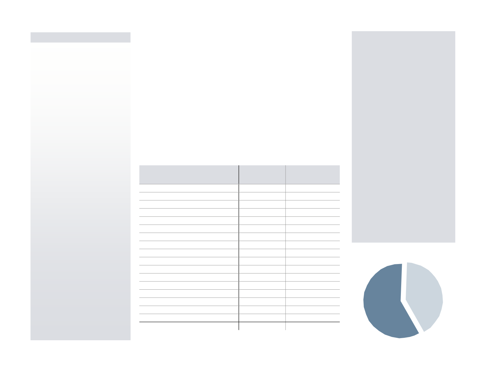
Developed
Acres
59%
Undeveloped
Acres
41%
PLANNING ISSUE
Growth will continue in both
rural and developed areas of
Montgomery County. This
growth will create opportunities
for improvement as well as
additional community impacts.
What’s New
It’s no surprise that single-family
detached homes use more land per
person than any other residential
category:
•
Single-family detached home
acreage accounts for 90% of all
residential land acreage even
though the number of detached
units is 55% of the total units in
the county as of 2010.
•
Single-family detached home
acreage also accounts for the
highest overall percentage of
county land at over 35% and that
doesn’t include the roads that
service the homes.
•
Multifamily and single-family
attached developments, such as
condos, apartments, and
townhomes, are more efficient
users of residential land with an
approximate density of 24.2
persons per acre. Detached home
development accommodates only
4.4 persons per acre.
Existing Land Use
Land Use Changes:
1970 - 2010
Regionally Significant Land Uses
Types of Landscapes
Land Use Trends
Existing Land Use
Montgomery County features a rich diversity of places and uses. Older towns
and main streets formed before the advent of the automobile are entrenched
alongside farmland and wooded areas holding on to their rural character. These
places exist while even more acreage is devoted to the suburbanization patterns
that fueled the county’s rise to become Pennsylvania’s third most populated
county. Two-thirds of the county’s developed land is used for residential
purposes, and the county also features significant amounts of commercial,
office, industrial, and institutional acreage that allowed it to become the
economic driver it is today within the Philadelphia region.
The county is represented by its range of uses and the relatively small space in
which these uses change. Major office or retail segues into single-family
detached homes, then to open land or low-density development, and then back
to a retail hub or manufacturing area. This variety reflects historic development
patterns, based on both railroads and highways, and has been impacted by the
county’s 62 municipalities making their own planning and zoning decisions.
LAND USE
TOTAL
ACREAGE
PERCENT OF TOTAL
COUNTY LAND
Single-Family Detached
80,345
25.8%
Single-Family Detached - Low Density (< 1 unit/acre)
29,962
9.6%
Single-Family Attached
8,419
2.7%
Multifamily
3,392
1.1%
Mobile Homes
600
0.2%
Transportation
22,044
7.1%
Utility
1,566
0.5%
Retail
5,872
1.9%
Office
5,648
1.8%
Mixed Use
1,877
0.6%
Institutional
13,015
4.2%
Industrial
9,973
3.2%
Mining
954
0.3%
Recreation and Parkland Fields
16,806
5.4%
Wooded
58,147
18.6%
Vacant / Agriculture
49,617
15.9%
Water
3,607
1.2%
Total
311,844
100.0%
FIGURE 32:
2010 Existing Land Use Acreage
FIGURE 33:
Land Use Coverage (2010)
Sources: Montgomery County Planning Commission, Delaware Valley Regional Planning Commission


